A deep dive into one of Cusco’s most underrated archaeological sites
Arriving at a Fortress Hanging Above the Canyon
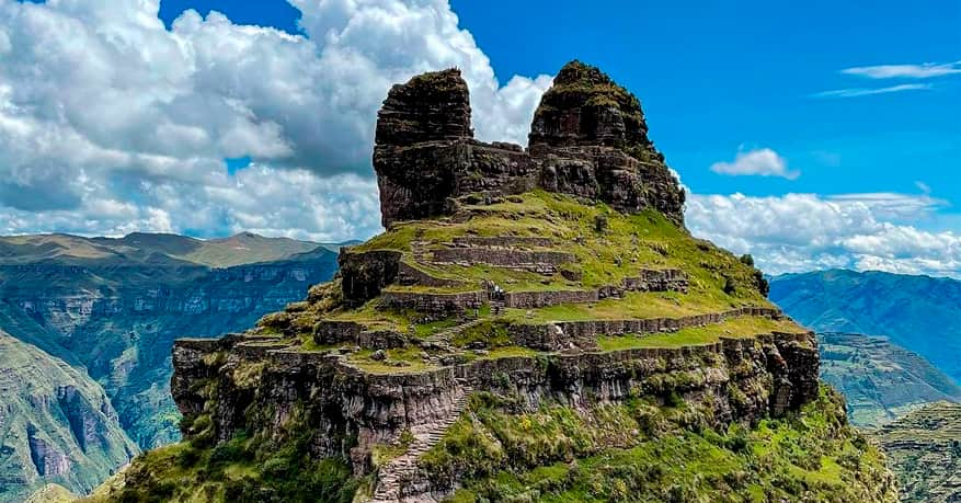
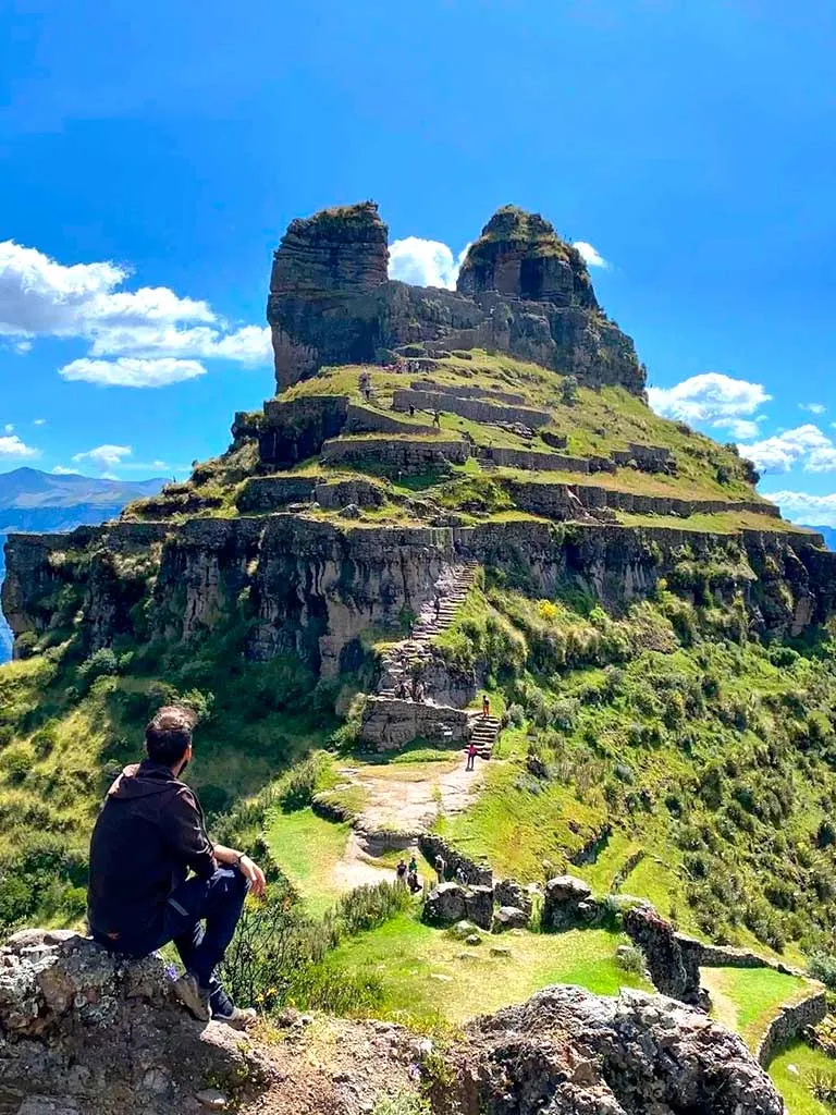
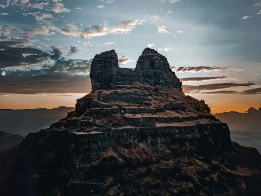
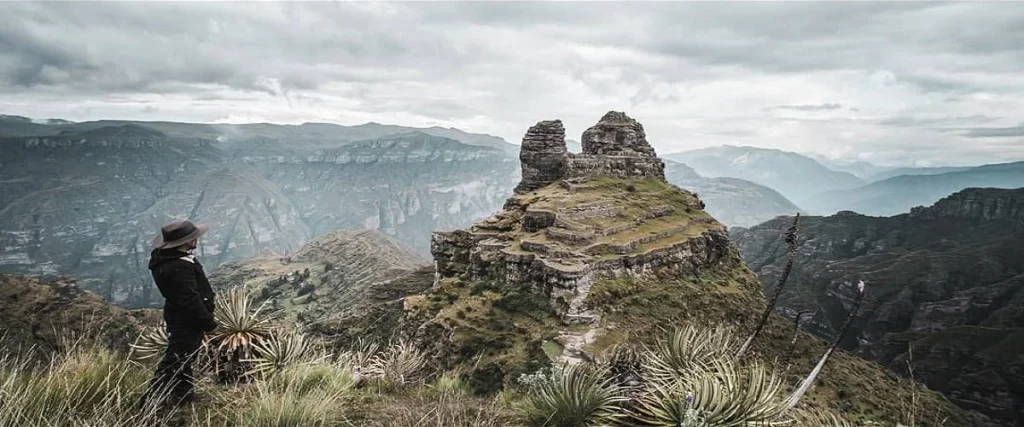
Reaching Waqrapukara feels different from most day trips around Cusco. As you approach the final ridge, the landscape suddenly opens and the fortress appears, sitting on a narrow rock platform, suspended above a canyon that drops thousands of meters into the Apurímac River. The twin horn-shaped rock towers rise behind it, giving the site its name: Waqra = horn, Pukara = fortress. It’s remote, quiet, and visually striking.
- No crowds.
- No vendors.
- No noise.
Just wind, cliffs, and an Inca site built on a place that almost seems intentionally unreachable. Waqrapukara lies farther from Cusco than mainstream destinations, which is why so few travelers make it there. But those who do are rewarded with a landscape and atmosphere that feel genuinely untouched, a type of experience that’s becoming rare around major Andean destinations.
Why Visit Waqrapukara?
Because it combines archaeology, isolation, and scenery in a way few places do. Machu Picchu impresses with scale; Waqrapukara impresses with audacity, the Incas built this fortress on a ledge that looks nearly impossible to access.
Stats
- 4,150 m / 13,615 ft above sea level
- High altitude conditions year-round
- Cold, dry wind exposure at the viewpoint and summit
Routes to Waqrapukara
There are multiple access points, each with different distance and difficulty levels:
1. Santa Lucía Route (Most Popular)
- Distance: 15 km roundtrip
- Duration: 6–7 hours
- Difficulty: Moderate
- Highlights: Open puna landscapes, views of the Apurímac canyon
2. Pomacanchi Route (Shorter but Steeper)
- Distance: 8–10 km roundtrip
- Duration: 4–5 hours
- Difficulty: Moderate to challenging
- Highlights: Direct access to the ridge near the site
3. Sangarará Route (Longest and Most Scenic)
- Distance: 18 km
- Duration: 7–8 hours
- Difficulty: Challenging
- Highlights: High-altitude lakes, Andean camelid herds, dramatic canyons
Difficulty
- Mostly moderate, but altitude plays a major role
- Trails mix dirt, rock steps, and exposed ridge sections
- Some steep descents approaching the site
- Not ideal for travelers without acclimatization
What to Bring
- Layers for changing temperatures
- Windbreaker
- Sun protection (high UV index)
- Snacks + at least 1.5L water
- Hiking poles recommended
- Gloves + hat in dry season mornings
- Phone battery pack for photos
- Entrance ticket or cash for community-controlled access (varies by route)
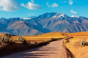
Weather
Dry Season (April–October)
- Clear skies and the most stable conditions
- Cold mornings + strong sun midday
- Best visibility for photography
Rainy Season (November–March)
- Greener landscapes
- Higher risk of storms and muddy trails
- Trek becomes more demanding but still doable with proper gear
Best Photography Spots
- The main viewpoint right before descending to the fortress (iconic “horned” skyline)
- Terraces facing the Apurímac Canyon
- The platform behind the ceremonial area where the canyon opens in both directions
- The horns (waqras) at sunrise or late afternoon
Pro tip: Bring a wide-angle lens, the scale of the canyon is bigger than it looks.
10 Things You Didn’t Know About Waqrapukara
1. Its Name Is Literal
Waqra = horn and Pukara = fortress, referring to the twin rock towers rising above the site.
2. It’s Older Than You Think
Before the Incas, the Qanchis culture occupied the region and likely built the earliest structures.
3. It Was a Strategic Frontier Post
Waqrapukara controlled movement between highlands and the deep Apurímac canyon, an important geopolitical border.
4. It Includes A Ritual Complex
The terraces and carved platforms indicate ceremonial use, not just military purpose.
5. It’s One of the Few Sites With a Natural Rock “Crown”
The horns weren’t carved, they’re volcanic formations the Incas intentionally incorporated.
6. The Canyon Beneath It Drops Over 2,000 Meters
One of the deepest canyons in Peru, giving the fortress unmatched visibility.
7. There’s Evidence of Astronomical Alignment
Some platforms face solstice sunrise angles, suggesting ritual calendar use.
8. It Was “Rediscovered” Only in the Late 20th Century
Local communities knew of it, but formal archaeological documentation is recent.
9. Llamas Still Graze in the Same Terraces the Incas Used
The area around the fortress is active pastureland managed traditionally.
10. It Receives a Fraction of the Visitors of Rainbow Mountain
On many days you may share the place with fewer than 10 people, a rarity near Cusco.
How to Visit Waqrapukara
For travelers who want a site that feels remote, authentic, and visually dramatic, Waqrapukara is one of the best choices near Cusco. It combines archaeology, mountain scenery, and solitude in a way that stands out even in a region full of extraordinary places.
The hike is straightforward with proper acclimatization, and visiting with a certified guide adds context about its architecture, history, and the communities that maintain the surrounding territory.
Check our day tour to Waqrapukara here.