An immersive journey into Peru’s last great Inca stronghold.
The Journey into the Cradle of Gold
There’s a moment on the road to Capuliyoc where the mountains suddenly the Apurímac Canyon reveals in front of you. impossibly deep and blue in the morning haze. The air warms, the horizon drops, and you feel stepping into one of Peru’s wildest, loneliest, and most rewarding journeys.
The Choquequirao Trek is a pilgrimage carved into the bones of the Andes.
For days, you descend into heat and climb into cold. You pass orchids drifting in the wind, abandoned terraces glowing in late-afternoon light, and ridgelines that feel like they belong to another century.
Why Trek to Choquequirao?
People come here for one reason: to experience something untouched.
Choquequirao is often called the “sister city of Machu Picchu,” but that’s only half of its truth. What defines this place is solitude. You don’t hear tourist chatter in its plazas, instead, you hear the wind brushing through ichu grass, and your own heartbeat.
The “why” is simple:
- Because the trail is challenging and equally rewarding.
- Because the ruins are vast and uncrowded.
- Because the Apurímac Canyon is one of the most dramatic landscapes in the Andes.
- Because sometimes you want a journey that still feels like an expedition.
This trek is for travelers who crave authenticity and don’t mind the burn in their legs.
Where Is Choquequirao?
Choquequirao lies deep in the Vilcabamba Range, the same mountain chain that shelters Machu Picchu and Salkantay. It hangs on a high ridge above the Apurímac River, isolated by steep canyon walls and old Inca pathways that stitch the slopes together.
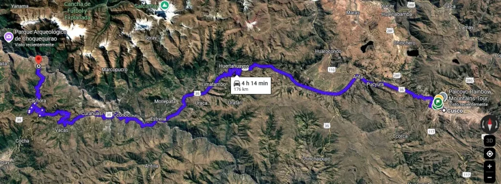
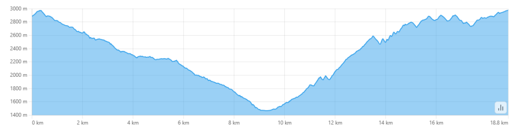
From Cusco, it sits roughly 150 km to the northwest, far enough to feel remote but close enough for a 5-day return trek. Its altitude shifts dramatically:
- Capuliyoc: 2,900 m
- Apurímac River: 1,500 m
- Choquequirao: 3,050 m
This constant rise and fall shapes the entire experience.
How to Get There
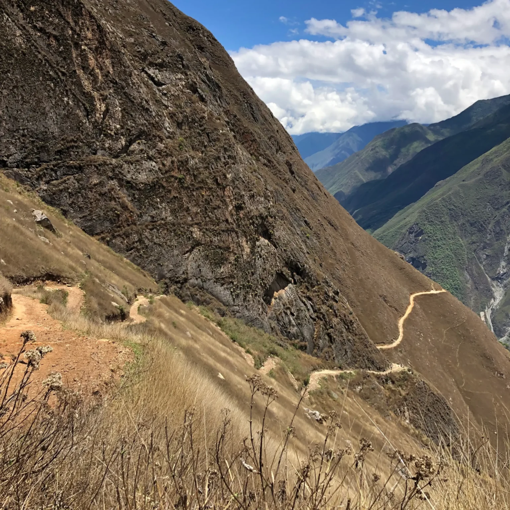
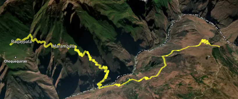
The classic access point is Capuliyoc, a viewpoint above the canyon reached by road from Cusco. From here, the trail drops sharply toward Chiquisca and the river, then climbs toward Marampata and finally the citadel.
You can trek independently or join a guided team. Most multi-day expeditions include:
- Mule support for gear
- A cook and camp team
- All meals
- Tents or simple accommodations along the route
For those seeking alternatives, a newer route connects Choquequirao to Yanama, allowing trekking loops or extensions toward Machu Picchu. I’ll go over it deeply later.
When Is the Best Time to Trek Choquequirao?
Dry season (May–September) is ideal: crisp mornings, clear ruins, stable trails.
Shoulder seasons (April & October) offer beautiful conditions and fewer people, with some rain.
Rainy season (November–March) brings lush vegetation and intense showers, the canyon becomes hot and slippery, and some cloud-forest sections turn muddy.
If you want the perfect combination of weather and tranquility: late May or early June is magic.
Essential Packing List
Choquequirao is a trek of extremes: heat in the canyon, cold nights above 3,000 m, and humidity in the cloud forest. Pack for all 3.
Essentials:
- Strong trekking boots
- Lightweight, breathable clothes + warm layers
- Trekking poles (highly recommended for steep descents)
- Sun protection (hat, glasses, sunscreen)
- Rain gear
- Hydration system
- Snacks & electrolytes
- Headlamp
- Toiletries + wet wipes
- Insect repellent
- Small medical kit
Optional but useful:
- Binoculars
- Photography gear
- Quick-dry towel
- Sandals for camp
Route Difficulty & What to Expect
Choquequirao is considered one of Peru’s more demanding classic treks. The challenge is not precesily the altitude, but it’s gradient.
You descend nearly 1,500 meters on Day 1, then climb most of that back on Day 2. The switchbacks can feel endless. The heat can be strong. And the final push to the ruins is steep. If you’ve done Salkantay or Ausangate, expect Choquequirao to be shorter but steeper. If this is your first big trek: go slow, hydrate, and start early.
But the reward? Standing alone on a terrace at sunrise, overlooking the canyon as the ruins glow gold.
Sample Itinerary
Check the full tour website here.
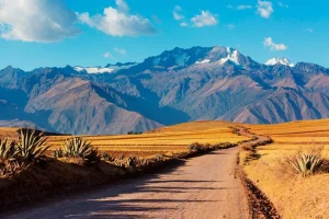
Day 1: Cusco – Capuliyoc – Chiquisca – Playa Rosalina
Early departure from Cusco to Capuliyoc.
The trail drops through switchbacks into warm canyon terraind: dry, golden, filled with agaves and shrubs. After hours of descent, you reach Chiquisca and continue to Playa Rosalina by the river. First night near the Apurímac.
Day 2: Playa Rosalina – Santa Rosa – Marampata – Choquequirao
The hardest climb of the trek begins.
A steep ascent from the river to Santa Rosa, then to Marampata, where the world suddenly opens. After a final traverse, you reach the campsite just below Choquequirao.
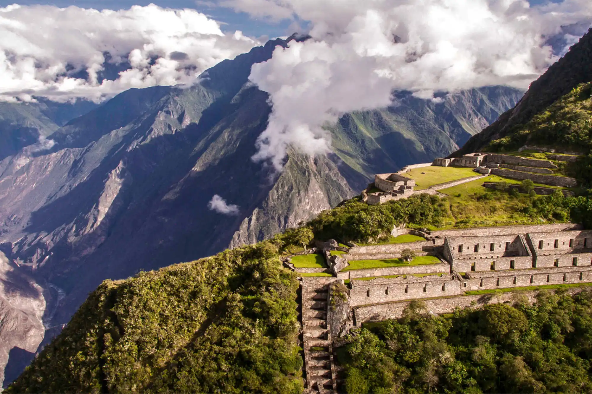
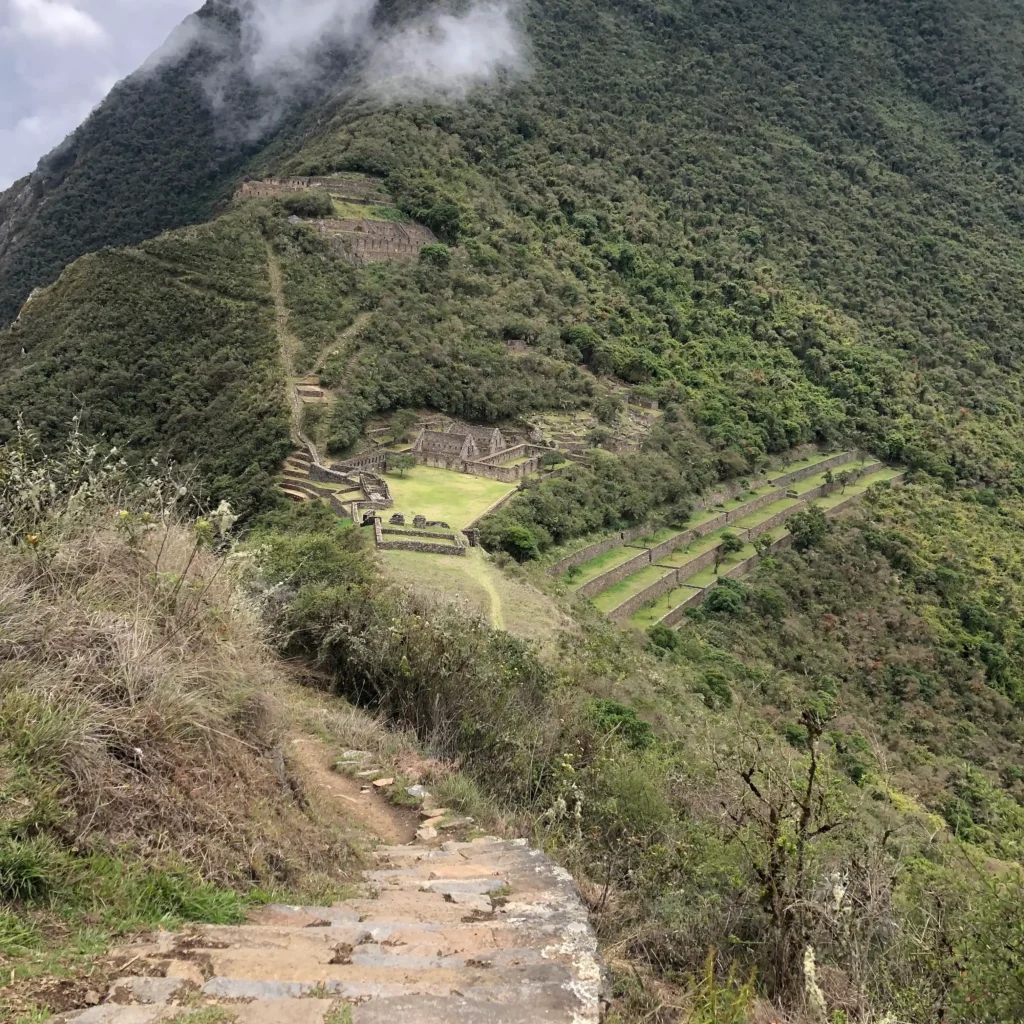
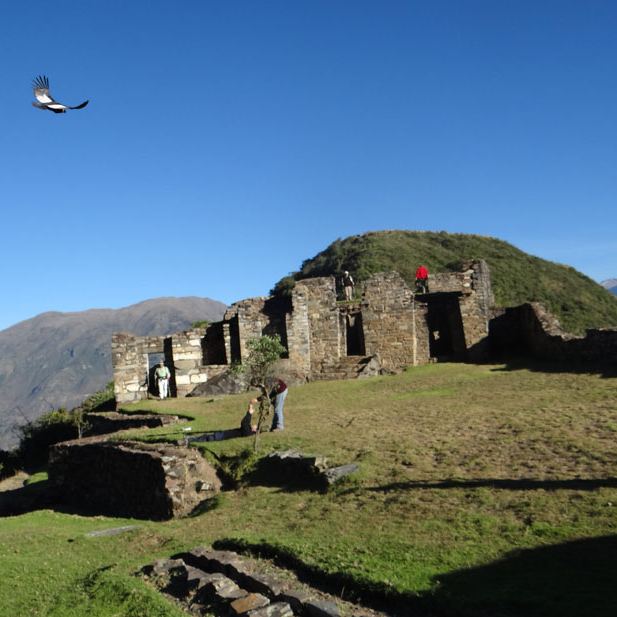
Day 3: Full Day Exploring Choquequirao
A day dedicated to one of the grandest Inca sites in Peru.
Terraces, ritual platforms, the llama carvings, upper and lower sectors, and few people to share them with.
Day 4: Return to Marampata – Santa Rosa – Chiquisca
Back down through the switchbacks, passing green terraces and warm canyon air.
Day 5: Chiquisca – Capuliyoc – Cusco
Final ascent to Capuliyoc. A last look at the canyon. Return drive to Cusco.
Additional Routes & Extensions
Choquequirao and the surrounding area is in the Vilcabamba Range, same as Machu Picchu. If you are looking for an alternative way to arrive to Choquequirao or interested in a combined experience to Machu Picchu, here are a couple of options:
The New Yanama → Choquequirao Route
This recently opened route cuts the approach significantly and brings trekkers through dense cloud forest. It links naturally with the Santa Teresa / Yanama side, making an approach from Cusco available now.
Novelties for hikers doing this trail include domes offered at the Cloud Forest, a comfortable and panoramic way to rest in the middle of demanding days on the trail going to or coming from the “Cradle of Gold.”
The Classic Choquequirao → Machu Picchu Trek
The legendary traverse from Choquequirao to Machu Picchu is one of the most ambitious multi-day hikes in Peru, weaving nearly 75 km of wilderness between two of the most important Inca citadels.
Once you leave Choquequirao behind, the route stretches across the remote Vilcabamba range. Steep ridgelines, forgotten passes, and valleys warming into high jungle. The first section crosses Abra Choquequirao and descends into Totora and the green Sahuayaco valley. Expect impressive contrasts: Puna landscapes one day, Waterfalls and Orchids the next.
Travelers often stop in Totora, Collpapampa, or La Playa depending on pace, each offering a clear shift in climate and scenery. In recent years, the rugged crossing has been softened slightly by dome-style glamping options around Colpapampa, a warm bed exactly where trekkers need it most.
Altitude Map & Elevation Profile
While your outfitter provides full charts, here is the general flow:
- Capuliyoc: 2,900 m
- Apurímac River: 1,500 m
- Marampata: 2,900 m
- Choquequirao: 3,050 m
Wildlife & Scenic Highlights
Along the route, you may spot:
- Andean condors riding thermal currents
- Hummingbirds drifting through cloud forest
- The occasional spectacled bear (rare, but possible!)
- Orchids, bromeliads, and wildflowers
- Massive terraces suspended above the canyon
- Panoramas of the Apurímac River cutting its way through the earth
Tips for Making the Most of the Trek
- Start early to avoid canyon heat.
- Hydrate constantly. The dry-air + sun combo is deceptive.
- Use poles on descents to protect your knees.
- Take breaks at viewpoints. The canyon deserves your time.
- Visit the ruins at sunrise or late afternoon for magical light.
- Don’t rush the climb to Marampata, slow is fast here.
Responsible Trekking & Conservation
Choquequirao is still being excavated and is far more fragile than it looks. Respect trails, avoid stepping on terraces, pack out all waste, and treat the site with the reverence it deserves.
Final Thoughts
Choquequirao is an integral reward, with natural beauty, impressive archeological remains, and a deep back country adventure.
Long after your legs stop aching, you’ll remember the way the mountains opened, the way the air changed, and the way Choquequirao was such a deep learning experience.